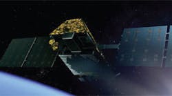
Satellite Constellation Studies Earth’s Surface
OpenConstellation 1.0 is a generation of satellites for Earth observation capable of providing critical intelligence in less than 30 minutes. The satellite constellation employs on-board artificial intelligence (AI) and Internet of Things (IoT) payloads to provide inter-satellite communications that provide timely observations of Earth’s surface.
Developed by Open Cosmos using these latest tools, OpenConstellation enables near real-time monitoring of disasters, security threats, and environmental changes.
Rafel Jordá Siquier, founder and CEO of Open Cosmos, said, “The world’s biggest challenges are moving faster than ever — from natural disasters and security threats to environmental change and critical infrastructure risks. But access to timely satellite intelligence has not kept pace.”
Siquier added, “By combining rapid tasking, onboard AI processing, and folding in the broadband layer from our ConnectedCosmos constellation and other third-party partner connectivity providers, we can deliver actionable Earth insights in as little as 30 minutes.”
The quick turnaround times aid government and enterprise executives in making critical decisions regarding events and locations.
Initial satellites for OpenConstellation 1.0 are being built across facilities in the United Kingdom, Spain, Greece, and Portugal. They will be launched throughout 2026, demonstrating Open Cosmos’ pan-European manufacturing capabilities.
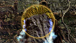
OpenConstellation 1.0 uses hyperspectral and high-resolution multispectral imaging for detailed Earth analysis (see image above). The satellite constellation is destined to capture as much as 3 million km2 of Earth data per day. The data is processed by means of onboard AI and satellite-to-satellite communications links for clarity and speed in data transfers.
Learn more about high-altitude Earth monitoring


About the Author
Jack Browne
Technical Contributor
Jack Browne, Technical Contributor, has worked in technical publishing for over 30 years. He managed the content and production of three technical journals while at the American Institute of Physics, including Medical Physics and the Journal of Vacuum Science & Technology. He has been a Publisher and Editor for Penton Media, started the firm’s Wireless Symposium & Exhibition trade show in 1993, and currently serves as Technical Contributor for that company's Microwaves & RF magazine. Browne, who holds a BS in Mathematics from City College of New York and BA degrees in English and Philosophy from Fordham University, is a member of the IEEE.