Eight Satellites Help ESA Track Disasters from Space
Open Cosmos of Barcelona, Spain unveiled plans for eight new Earth observation satellites to boost views of forest fires and climate-related natural disasters from space for the European Space Agency (ESA) as part of the ESCA system. The addition will extend the total to 16 satellites in the ESA’s Atlantic Constellation for strong access from Spain and Portugal.
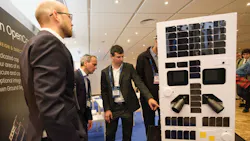
Open Cosmos revealed that they have passed the critical design review (CDR) stage of the satellites’ and their ground segments’ development, and now the units are ready for production. The development model for the compact satellites (see image above) will be donated to the Spanish Space Agency (AEE) headquarters in Seville, Portugal.
Tiago Rebelo, CRO of Open Cosmos, who presented details on the final design of the eight satellites, noted, “Passing the Critical Design Review is a key milestone for a program of ESCA's complexity and ambition. It confirms that the system is ready to make the leap to the production phase and reflects the enormous joint work of Open Cosmos and the entire Spanish industrial and scientific consortium.”
Of the complex ESCA work, he added, “This project shows that Spain has the technological, industrial, and coordination capacity necessary to lead strategic Earth observation missions with a real impact on society.”
Concerning the significance of the ESCA program and the 16 satellites, Cecilia Hernández, Director of Programs and Industry at the Spanish Space Agency, commented, “The Atlantic Constellation is a strategic cooperative effort, bringing together Spain, the European Space Agency, and the Government of Portugal. With ESCA, Spain is promoting its own Earth observation technologies, strengthening its technological autonomy, and consolidating high-value national industrial capabilities in a key area for European technological sovereignty.”
Learn more about Earth monitoring and wildfire response


About the Author
Jack Browne
Technical Contributor
Jack Browne, Technical Contributor, has worked in technical publishing for over 30 years. He managed the content and production of three technical journals while at the American Institute of Physics, including Medical Physics and the Journal of Vacuum Science & Technology. He has been a Publisher and Editor for Penton Media, started the firm’s Wireless Symposium & Exhibition trade show in 1993, and currently serves as Technical Contributor for that company's Microwaves & RF magazine. Browne, who holds a BS in Mathematics from City College of New York and BA degrees in English and Philosophy from Fordham University, is a member of the IEEE.