NASA Fights Forest Fires with Drone Aircraft
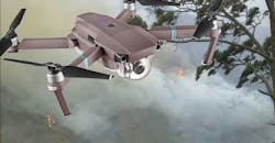
Forest fires can be difficult to track, especially with strong, changing winds steering those fires in unpredictable directions. However, NASA has worked with sensors mounted on small drone aircraft to gather data from above on spreading forest fires, using the sensors to predict the path of major forest fires. Working in partnership with the U.S. Forest Service and the Bureau of Land Management, NASA and its Ames Research Center has adapted unmanned aerial vehicles (UAVs) and a variety of different sensors for environmental research, specifically to predict the paths of active forest fires.
One of the key concerns in battling these blazes involved moving data from the unmanned aircraft to ground-based research centers. Initially, low-Earth-orbit (LEO) satellites were considered an efficient means of transferring environmental sensor data, such as thermal sensor data. The use of satellites would allow the communications of data across oceans but, because U.S.-based forest fires are on land, the desire was to move sensor data from the UAVs to ground stations. The use of aircraft-to-ground links would provide more bandwidth than existing LEO satellites.
NASA reached out to Gogo Business Aviation (formerly Aircell), a private wireless-networking company unaffiliated with NASA, to provide the communications links from the uncrewed aircraft to the ground. While the U.S. Forest Service continues to rely on its crewed aircraft for data from active forest fires, it’s also experimenting with NASA and the uncrewed aircraft equipped with the thermal sensors for gathering and transferring thermal data on forest fires in near real time. Access to such thermal data provides invaluable guidance to Forest Service Managers responsible for sending firefighting resources as well as issuing warnings when evacuations for difference forest lands are required.
See “Remote Sensing for Smarter Forest Fire Fighting,” NASA Tech Briefs, Vol. 42, No. 7, July 2018, p. 64.

About the Author
Jack Browne
Technical Contributor
Jack Browne, Technical Contributor, has worked in technical publishing for over 30 years. He managed the content and production of three technical journals while at the American Institute of Physics, including Medical Physics and the Journal of Vacuum Science & Technology. He has been a Publisher and Editor for Penton Media, started the firm’s Wireless Symposium & Exhibition trade show in 1993, and currently serves as Technical Contributor for that company's Microwaves & RF magazine. Browne, who holds a BS in Mathematics from City College of New York and BA degrees in English and Philosophy from Fordham University, is a member of the IEEE.