Navigation System Flies on U.S. Army Black Hawk
The Blacknaute Inertial Navigation System (INS) from Safran Federal Systems successfully demonstrated its capabilities while flying onboard a U.S. Army UH-60 Black Hawk helicopter. The INS provides an effective means of navigation on environments deprived of Global Positioning System (GPS) signal access and contested by adversarial electronic-warfare (EW) systems.
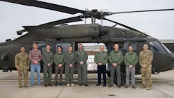
The live flight test (see image above) took place shortly after the debut of the Blacknaute at the 2025 Association of the United States Army (AUSA) Annual Meeting & Exposition in Washington, DC.
Safran's Alexandre Ziegler, Executive Vice President, Defense Global Business Unit, said, “Our demonstration onboard the Army Black Hawk showcases the tactical readiness of Blacknaute. The system maintained drift of less than 0.4 nautical miles per hour over several hours — proof of its SWaP-optimized, NAVWAR-resilient design engineered for rapid deployment across the Joint Force.”
The Blacknaute system, which weighs less than 16 lbs., employs Safran’s hemispherical resonator gyro (HRG) technology with a durable atomic clock for long expected operating lifetime. The system is equipped with interference detection and mitigation (IDM) to overcome overcrowded signal environments.
Blacknaute has already been installed in more than 40,000 navigational systems to log more than 30 million operational hours. It performs navigation via multiple-constellation satellites and military-grade M-Code signals. The open architecture is fully compliant with MIL-STD interfaces and TSO-C220 standards for ease of installation in a wide range of applications.
Learn more about navigation systems


About the Author
Jack Browne
Technical Contributor
Jack Browne, Technical Contributor, has worked in technical publishing for over 30 years. He managed the content and production of three technical journals while at the American Institute of Physics, including Medical Physics and the Journal of Vacuum Science & Technology. He has been a Publisher and Editor for Penton Media, started the firm’s Wireless Symposium & Exhibition trade show in 1993, and currently serves as Technical Contributor for that company's Microwaves & RF magazine. Browne, who holds a BS in Mathematics from City College of New York and BA degrees in English and Philosophy from Fordham University, is a member of the IEEE.