Phone App Captures Data Using Photogrammetry, LiDAR, and Depth Sensors
This video appeared in Electronic Design and has been published here with permission.
Check out our AUVSI Xponential 2023 coverage.
Pix4D provides surveying and mapping solutions that are commonly used to create digital twins, create maps, and analyze everything from crops for precision agriculture to checking the reliability of bridges. The company utilizes 3D scanning technologies like LiDAR to build 3D images.
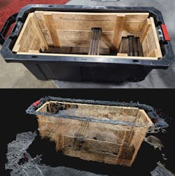
Tom Cerchiara, Senior Technical Sales Engineer with Pix4D, shows off its handheld scanner that links to a smartphone for close-in scanning (watch the video above). It can generate a 3D image by simply walking around an area or object (Fig. 1). In this case, a digital twin of a tub was generated by walking around it with the scanner. All of the action takes place in the cloud that analyzes the raw 3D position and scanning data.
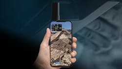
The demo in the video uses the handheld viDoc RTK rover scanner (Fig. 2) and the PIX4Dcatch software. This attaches to a smartphone that provides the link to the cloud as well as runs the app for the scanner. The 3D scanner is used to detect local objects and the sensors in the system detect the movement and position so that the software can generate an accurate 3D map of the object and area.
The handheld scanner is only one of the many devices that can provide input to Pix4D's software, which is the key to the solution. Drones equipped with a similar scanner, radar, LiDAR, or 3D camera are common inputs to the software. The model's accuracy is based on the quality and precision of the input data, which includes the scanning hardware's position and orientation as well as the output from the sensor itself.
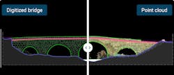
The generated assets can include details like the point cloud or vectors using export formats such as DXF for CAD applications and SHP for GIS applications. The software is designed to be integrated into workflows that can include multiple scans and sources. It's also able to blend data from different types of sensors and cameras (Fig. 3).
This type of information can be used to identify problems, provide an understanding of current conditions, and offers insights that would otherwise be difficult to understand or explain.
Links
The video transcript below has been edited for clarity.
Pix4D is a photogrammetry software company. We’ve been making photogrammetry software since 2011. We originally focused on using drone photogrammetry data to make three-dimensional maps for engineering, surveying, construction applications, and we've been very successful with that. Our software is some of the most accurate out there. Our newest product is PIX4Dcatch RTK system, and that is an app for your mobile phone that allows you to 3D scan data using photogrammetry and, if available, LiDAR and depth sensors.
And the second part of it is the viDoc RTK rover, which snaps onto the back of your phone and gives you RTK accuracy for all that imagery and LiDAR collection that you're doing. So essentially, think of it as an RTK drone in your hands.
Its use cases are trench builds, specifically in utilities and facilities, and things like that for stockpile volumes on construction projects, for accident reconstruction, for car accidents, and crime-scene reconstruction and documentation. It’s really good for small scans for areas that the drones can't reach or you don't want to bring the drones into for whatever reason, and it still allows you to get highly accurate photogrammetric scans.
When it's done, you get a preview right here of your scan. This is just to make sure you've covered all the right area and then you can use the upload button here to upload to our cloud to do the post-processing of the data to get the highly accurate stuff. Or you can export it to a USB stick or one drive, a G-drive, or something like that.
I've proven e-accuracy of larger scans to the area of two to three centimeters of absolute accuracy. Relative accuracy can be even tighter than that. And on small areas for individual scans, say, like a structural inspection of a bridge or something like that, I've proven e-accuracy down to sub-millimeter.
Check out more of our AUVSI Xponential 2023 coverage.
About the Author

William G. Wong
Senior Content Director
I am Editor of Electronic Design focusing on embedded, software, and systems. As Senior Content Director, I also manage Microwaves & RF and I work with a great team of editors to provide engineers, programmers, developers and technical managers with interesting and useful articles and videos on a regular basis. Check out our free newsletters to see the latest content.>
You can send press releases for new products for possible coverage on the website. I am also interested in receiving contributed articles for publishing on our website. Use our template and send to me along with a signed release form.
Check out my blog, AltEmbedded on Electronic Design, as well as his latest articles on this site that are listed below.
You can my social media via these links:
- AltEmbedded on Electronic Design
- Bill Wong on Facebook
- @AltEmbedded on Twitter
- Bill Wong on LinkedIn
I earned a Bachelor of Electrical Engineering at the Georgia Institute of Technology and a Masters in Computer Science from Rutgers University. I still do a bit of programming using everything from C and C++ to Rust and Ada/SPARK. I do a bit of PHP programming for Drupal websites. I have posted a few Drupal modules.
I still get a hand on software and electronic hardware. Some of this can be found on our Kit Close-Up video series. You can also see me on many of our TechXchange Talk videos. I am interested in a range of projects from robotics to artificial intelligence.