UPDATE: SBIRS GEO Satellites Track Missiles Using Infrared Data
Update: The U.S. Air Force has awarded a $1.86 billion contract to Lockheed Martin for the complete production of the fifth and sixth Space Based Infrared System (SBIRS) Geosynchronous Earth Orbit (GEO) satellites: GEO-5 and GEO-6. SBIRS helps provide the country with continuous early warnings of ballistic missile launches and other tactical intelligence.
Previously: Infrared satellites have proven viable as part of the ongoing mission to enhance tactical intelligence capability. To buoy this effort, the second SBIRS GEO satellite was recently declared operational. The SBIRS GEO-1 and -2 satellites aim to deliver continuous and accurate missile warnings and infrared surveillance information to combat commanders, the intelligence community, and other key decision makers.
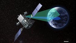
To improve the quality of infrared data collection, SBIRS performs a series of steps. When a missile is launched, the SBIRS sensors detect and track the infrared radiation from its hot exhaust. The satellites then process and transmit that data to the ground terminals. From there, it is forwarded to the Mission Control System (MCS). The MCS receives all data from the sensors, combining data from the multiple satellites and payloads to increase accuracy and aiding in processing and management of the constellation. Next, launch reports are generated with information including the type of missile, its launch point, time, azimuth, and the predicted impact point. Launch reports are reviewed by Air Force Space Command operators and released to strategic, tactical, and technical intelligence users. Later, wideband data can be played back for better understanding of the missile’s performance and to add updates to the database.
The SBIRS architecture includes a mix of satellites in GEO, hosted payloads in highly elliptical orbit (HEO), and ground hardware and software. The ground system performs five main functions: mission planning/payload tasking, constellation management, mission processing, event reporting and data distribution, and ground control. It is operable in three modes: normal, survivable, and endurable. In conjunction with the satellites and payloads, the ground system provides enhanced global, persistent coverage and missile-launch detection. These aspects help to support ballistic-missile defense systems and subsequently bolster situational awareness for warfighters in the field.
The SBIRS GEO satellites utilize a global positioning system (GPS) receiver with a Selected Availability Secure Anti-Spoof Module (SAASM) for secure communication of coordinates. The ~1000-lb. infrared payload of scanning and staring sensors includes short-wave, mid-wave, and see-to-ground sensor-chip assemblies. In addition, Short Schmidt telescopes provide dual-optical pointing, agile precision pointing and control, and passive thermal cooling.
The satellites rely on a mix of Earth antennas, omnidirectional antennas, and dual-band gimbaled spot beams. They operate on three frequency bands at Ka-band, three at S-band, and one at Q-band. The Ka-band is used for survivable mission data, normal mission data, and wideband sensor data. The S-band is utilized for theater mission downlink, backup space-ground-link-system (SGLS) telemetry downlink, and backup SGLS commanding. The Q-band is used for anti-jam commanding.
The HEO payloads perform similar functions to the GEO satellites for vital polar coverage. The ~600-lb. infrared payload includes a scanning sensor—also in short-wave, mid-wave, and see-to-ground sensor-chip assemblies--as well as the Short Schmidt telescopes, agile precision gimbal pointing and control, and passive thermal cooling. The payloads boast a data rate of 100 Mb/s to the ground.
All SBIRS satellites and payloads are currently under contract by Lockheed Martin. Three more satellites (and subsequent HEO payloads) are set for eventual launch. GEO-3 recently passed functional integration testing while GEO-4 is scheduled for delivery in 2015. The SBIRS team is led by the Infrared Space Systems Directorate at the U.S. Air Force Space and Missile Systems Center with operation led by the Air Force Space Command.
About the Author
Iliza Sokol
Associate Digital Editor
Iliza joined the Penton Media group in 2013 after graduating from the Fashion Institute of Technology with a BS in Advertising and Marketing Communications. Prior to joining the staff, she worked at NYLON Magazine and a ghostwriting firm based in New York.